STORM SURGE
Occurring with the passage of tropical storms and hurricanes,
storm surge is the mounding up of water, particularly on the
northeast quadrant of the storm, as it approaches the coast. The
northeast quadrant will be the most hazardous both because
of increased wind speeds and storm surge. Storm surge will be
higher with more intense storms; Hazel (Category 4 hurricane
in 1954) had a storm surge of 17 feet while Fran (Category 3
hurricane in 1996) had a storm surge of 10 feet. Storm surge is
usually the most damaging aspect of hurricanes, though as we
know from Floyd (1999) and Matthew (2016), flooding may
sometimes be the most costly and deadly.
TIDAL RANGE
Wrightsville Beach has a tidal range of approximately 4.5 feet.
There are two high and two low tides each day of approximately
equal magnitude; these are termed semi-diurnal tides. Storm
surge that coincides with the high tide or particularly with the
spring high tide will be much more damaging.
Our average wave heights are only 2-3 feet but in storms
they are much larger. These storm waves impact deeper water
and will put more of the sand into motion.
SEA LEVEL RISE
On short time scales, sea level rise and fall is very small;
though we know that sea level has varied dramatically over
time. Just 18,000 years ago sea level was approximately 400 feet
lower than today.
Sea level rise is an important issue on our low-lying coast.
A 2015 report by the Science Panel of the Coastal Resources
Commission was completed to provide current and projected
sea level rise along the coast. It states that Wilmington has a
yearly sea level rise currently of just over .08 inches per year.
Over a 30-year timeframe, which is the projection period
in the report, the rise in sea level would be approximately
2.5 inches in Wilmington. However, depending upon the
scenario, it may be as much as 5.4 inches. These sound like
small numbers but our coastline is very flat, which leads to
more areal flooding even with a small rise.
Most of North Carolina’s coastline has a moderate-to-high
vulnerability to sea-level rise. A rise of 14 inches would inun-date
44
WBM
more than 700 square miles, mostly in northeastern North
Carolina. Southeastern North Carolina is not as flat and our
rate of rise is less — geology does make a difference. As a point
of reference, the maximum elevation on Wrightsville is just over
10 feet with much of it less than 5 feet; the average is 7 feet.
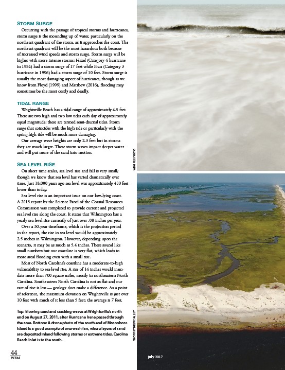
Top: Blowing sand and crashing waves at Wrightsville’s north
end on August 27, 2011, after Hurricane Irene passed through
the area. Bottom: A drone photo of the south end of Masonboro
Island is a good example of overwash fan, where layers of sand
are deposited inland following storms or extreme tides. Carolina
Beach Inlet is to the south.
PHOTO BY DREW SALLEY WBM FILE PHOTO
july 2017