Carolina Gold
The river-based rice plantations on Eagles Island
BY Pat Bradford

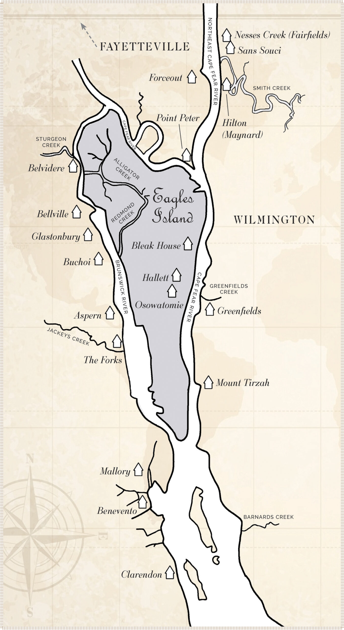
“Eagles Island encompasses over 3,000 acres and the north end of the island is made up of tracts owned by more than two dozen private residents, corporations and governmental agencies,” the Wilmington Star News Online states in 2024.

Joseph and Richard Eagles Sr. became prominent planters when they settled in the Lower Cape Fear area circa 1725. Eagles Island is named for them, not John Watson who was granted a section of the island in September 1735 by British King George II.
Less than two years later, Richard Eagles, a native of Bristol, England, and a merchant planter from Charles Town (later Charleston), was also granted a major portion of a “big island” and “great island” lying between the Cape Fear and Brunswick rivers opposite Wilmington, then a small village called Newton.
For early settlers, access to a waterway was essential. Rivers were the highways of the day for moving supplies, livestock, equipment and people. There were once more than 100 plantations with plantation landings along the Cape Fear River, with many others located inland in later years.
In 1738, a transfer of 540 acres to Eagles by John Watson was added to the original grant.
Richard married Elizabeth Crichton. Through marriage he was related to William Dry, who also owned land on Eagles Island and was noted by Maritime History and Survey of the Cape Fear and Northeast Cape Fear Rivers, Wilmington Harbor, North Carolina, Submerged Cultural Resources Survey by Glenn C. Overton, in a later will as having a brick house on the island.
Plantation owners who resided on the western bank of the Brunswick River could travel readily northward to Cross Creek (later Fayetteville) or southward by way of Brunswick Town into South Carolina. It was not uncommon for planters to own more than one plantation.
Eagles was one of these planters.
Eagles Plantation
The Eagles Plantation on what today is Eagles Island was located between the Cape Fear River and the Brunswick River, as well as land in Brunswick County. An early map shows the site of a large brick house on Eagles Island.
Janet Schaw observed the house in 1775.
“I now observed that the road was enclosed on both sides, and on the first turning the carriage made, we found ourselves in front of a large house from the windows of which beamed many cheerful tapers, and no sooner we come up to the gate then a number of servants came out with lights. Mr. Eagles dismounted, ready to assist us, and now welcomed us to his house. We found the tea table set forth and for the first time since arrival in America had a dish of tea,” she wrote in a missive recorded in History of New Hanover County and the Lower Cape Fear Region by Alfred Moore Waddell.
Forks Plantation
Richard Eagles’s Forks Plantation was located below Wilmington just north of Clarendon Plantation. The Forks originally consisted of 6,500 acres on the west bank of the Cape Fear River with 700 acres of rice land located on Eagles Island.
His daughter Elizabeth’s husband, John Davis Jr., was deeded land on Eagles Island in 1757, but at Eagles’s death that same year his son Richard Eagles Jr. was his primary beneficiary.
Richard Eagles Jr. married Margaret Henrietta Bugnion. In 1765, he sold land on Eagles Island to Wilmington merchant Anthony Ward that had been part of the patent land that John Watson had sold to his father.
Eagles Jr. left “the House Plantation, saw & grist mills” at The Forks to his son, Joseph, circa 1769. His daughter Susanna, who would marry Alfred Moore, would inherit one-third of the land Eagles now owned on Eagles Island.
Joseph Eagles married Sarah Read Eagles and had two children. By 1784 Joseph Eagles was the owner of some 3,060 acres of land in Brunswick County. One of Joseph’s sons, Richard Eagles III, sold all of the land described as “being in Great Island opposite Wilmington and commonly called Eagles’ Island, except for 108 acres assigned to other heirs, to Maurice Moore of Brunswick County for $11,000,” according to Glenn C. Overton.
Richard Eagles III and Joseph Eagles Jr. died (in 1811 and 1827, respectively) without heirs.
The Forks Plantation remained in the Eagles family until 1853, when it was sold by John Winder and his wife, Caroline Ann Eagles Winder, to Thomas C. Mcllhenny for $45,500. The sale included The Forks and the remaining rice lands on Eagles Island.
Aspern Plantation
Thomas C. Mcllhenny was also the owner of Aspern and other plantations in the Lower Cape Fear region. In March 1880, he put Aspern up for sale after owning it for more than 20 years. The Wilmington Star, March 30, 1880, described 100 acres of rice land that could be increased to as much as 250 acres of production.
Glastonbury Plantation
A portion of Brunswick County’s Glastonbury Plantation on the west side of the Brunswick River included 220 acres of rice lands on Eagles Island. Capt. Augustus W. Rieger purchased Glastonbury Plantation at auction in 1869.
Hallett Plantation
During the two decades after the Civil War, B. F. Hallett owned a rice plantation on Eagles Island. It contained 60 acres and was described as “under the bank and ditch, with good trunks.” (Wilmington Star, Aug. 24, 1876).

Belvidere Plantation
(Spelling taken from “A History of New Hanover County and the Lower Cape Fear Region,” 1723-1800, vol. 1, by Alfred Moore Waddell, c. 1909.)
Belvidere owner William Jones placed an ad in the Wilmington Cape Fear Recorder, June 29, 1831, offering the plantation for sale.
“My ‘Belvidere’ plantation, formally the residence of General Smith, on the Cape Fear River in North Carolina. It lies opposite to and inside of and two miles from Wilmington on the stage road leading from Wilmington to Fayetteville and the road leading to Georgetown, South Carolina. … Improvement – On the premises are a comfortable and convenient two-story dwelling house and a building one and a half story with kitchen, wash house, stable, carriage house, smokehouse etc. A barn 110 feet long, 40 feet wide, two stories high in which a threshing machine, other machinery. Also overseer’s house and kitchen, all of which buildings are brick, put up in the most substantial manner. There’s another barn built of wood directly at the river from which the rice can be conveniently thrown into a flat or vessel and any vessel that can come over the bar can come to the barn.”
Buchoi Plantation
Buchoi was composed of land on the west side of the Brunswick River and on a portion of Eagles Island.
Judge Alfred Moore was the first owner. At his death in 1810, the plantation passed to his son, Alfred Jr., with a portion of the lands west of the river going to his daughter, Anne, and her husband, Maj. Hugh Waddell.
“The Waddells and his other daughter, Sarah, also received sizable tracts of land on Eagles Island, both above and below the causeway that crossed the island and provided access to the Wilmington ferry. In the early 19th century, a section of Buchoi was owned by W. C. Lord, who advertised the sale of the plantation in November 1838,” according to Glenn C. Overton.
Bellville Plantation
(Also identified as Belville spelling taken from “A History of New Hanover County and the Lower Cape Fear Region,” 1723-1800, vol. 1, by Alfred Moore Waddell, c. 1909.)
Owned by Gen. Hugh Waddell and later his son, John Waddell, Bellville Plantation was located on the Brunswick River above Glastonbury and also contained rice lands across the river on Eagles Island.
Bellville was described in detail, providing a general picture of plantation life, when it was advertised in the Wilmington Chronicle on Nov. 20, 1844.
“Will be sold at auction in Wilmington on the first day of January next, that well known Rice Plantation ‘Bellville’ situated on the West branch of the Cape Fear River, nearly opposite the town of Wilmington. There are near 200 acres of the swamp, well adapted to the culture of Rice, and most of it now in cultivation. These lands, as also those in the immediate neighborhood, are believed to be less liable to injury, either from freshets or salt water, than any on the river, being midway between the extreme points of the great island [Eagles Island] on which they for the most part be, and in an excellent pitch of the tide for draining and flowing. The Highland settlement is a most advantageous one, fronting one mile on the river, with a sufficiency of land in cultivation to support the hands necessary to the Rice Farm. Upon the premises is an excellent Dwelling House, containing eight rooms, as also all necessary out-building, a large Barn, Winnowing House, etc. “
Bellville was sold in the 1890s to Gov. Daniel L. Russell, who was unsuccessful in growing rice there. Mr. W.R. Boyd, superintendent of Gov. Russell’s plantation, announced in 1897 that worms had done considerable damage to the ricefields on Eagles Island. (Wilmington Messenger, July 15, 1897).
Bleak House
Bleak House, located on Eagles Island opposite Kidder’s Mill, was the property of H. U. Butters in 1899. The rice plantation was leased by the state penitentiary, which used convict labor. The Wilmington Messenger of Sept. 13, 1899, stated, “George H. Cannon, superintendent of the penitentiary farm, stated that the crop at Bleak House yielded from 40 to 50 bushels of rough rice per acre.”
A charter was issued Oct. 30, 1902, to the Cape Fear Rice Company, which owned two rice plantations on Eagles Island, Bleak House containing 120 acres of rice land, and Osawotomie Plantation, with 145 acres of rice land, cited the Wilmington Dispatch, Nov. 29, 1902.
Point Peter Plantation
Located at the fork of the Northeast and the Cape Fear River, Point Peter Plantation was owned in 1777 by Roger Moore. He sold a tract of land containing about 3,000 acres for 4,000 British pounds to Col. Peter Mallett and Arthur Magill.
“At that time the tract was well known by name of Negro Head Point in Forks of Northeast and Northwest Rivers. Two years later Magill sold his part of Negro Head Point to Mallett, who retained the property until 1787. From Mallett’s time forward it has been known as Point Peter. The name of this place has long been erroneously supposed to have been derived from the fact that a Negro’s head was said to have been stuck upon a pole there at the time of the Nat Turner insurrection in 1831, but this is a mistake,” states A History of New Hanover County and the Lower Cape Fear Region, 1723-1800, vol. 1, by Alfred Moore Waddell, c. 1909.
By 1842 Peter Point Plantation was sold again, listing 200 acres of rice cultivation producing an average yield of 75 bushels per acre. Waddell’s Plantation Architecture of The Lower Cape Fear, describes the plantation infrastructure to include “dwelling house, Brick kitchen, stable, Cow houses, Cooper shed, and sick house together with Cow lots and fine garden.”